
I'm almost caught up with image accounts now. This is the first of two accounts covering Monday June 15th 2009 when I observed two thunderstorms and two funnel clouds from Maghera, N. Ireland. I will keep this one as short as I can. It was the same story, high instability with fantastic CAPE and LI values combined with intense solar heating in a moist SWly flow thanks to a low pressure system situated over the Atlantic to the SW of Ireland. From the moment I woke up I was highly impressed by what seen in the sky. At 11.00 BST heavy showers were breaking out with fantastic structure due to such high instability. At stunning cell with low level chunky gust front with great towers passed over my home (I have images of this) and completely soaked the place. Once it cleared through the Sun began to heat the ground up even more so I knew this was going to be a good day. By the early afternoon I seen the most stunning convection I have ever seen in my life, even better than what I had seen during the last two days, and those sights would take some beating.
I have never seen such awesome exploding updraught towers and cells in all my life, in fact, I don't know how on Earth I could possibly describe or do them justice without you being here to witness them with your own eyes. I was still at home at this stage and watching over the back garden fence to the S where I seen the most impressive cells of my life. I was so stunned that I posted a rather excited comment on several of the weather forums saying something like...''OMG, the convection here is absolutely incredible, one would be forgiven for thinking these cells were tornado warned''. That's exactly what they looked like. There where two monster cells over Slieve Gallion to the S, and SE, which were absolute eye candy, I mean they were crazy with huge size, rock solid bodies and tops, well defined solid base like a mountain and the whole thing just exploding up into the sky like a mushroom cloud on a nuclear bomb. I couldn't believe my eyes, they looked similar to cells I had seen on youtube showing growing white storms from the US. I regret not making much of an effort to photograph these but my view was restricted due to other houses, all I got was this image below.
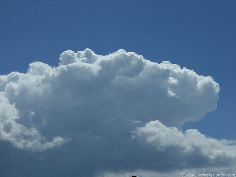 |
This was the only one I took from the garden, you can see the top of a chimney on the neighbour's roof. This was one of those incredible rock solid anvils which was back-sheared against the SWly flow. The upper level wind/flow was blowing from the R, however the anvil was leaning into this flow indicating powerful updraught strength within this cell. The anvil slopes down the the lower L out of frame and into the main body of the cell itself which went all the way down to near the surface. Look how solid and bubbly the top is, it was expanding by the sec. I watched these two cells move into the NE in the distance, however following behind where two more of the same standard!. These two looked capable of producing something and were on the verge of turning into storms so I headed out the road because I thought there was a high chance of one of these dropping a funnel, at the very least.
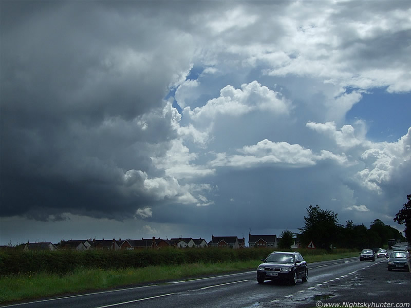 |
The view from the Coleraine Road looking directly S. The cells are moving from R to L. You can see the rear of the L cell with updraught towers at the rear, the cell behind looked even more fantastic with a large solid anvil head which you can just see on this image through gaps in the mid level cloud. Both cells were turning dark and releasing precip and about to bridge the gap from convection to storms.
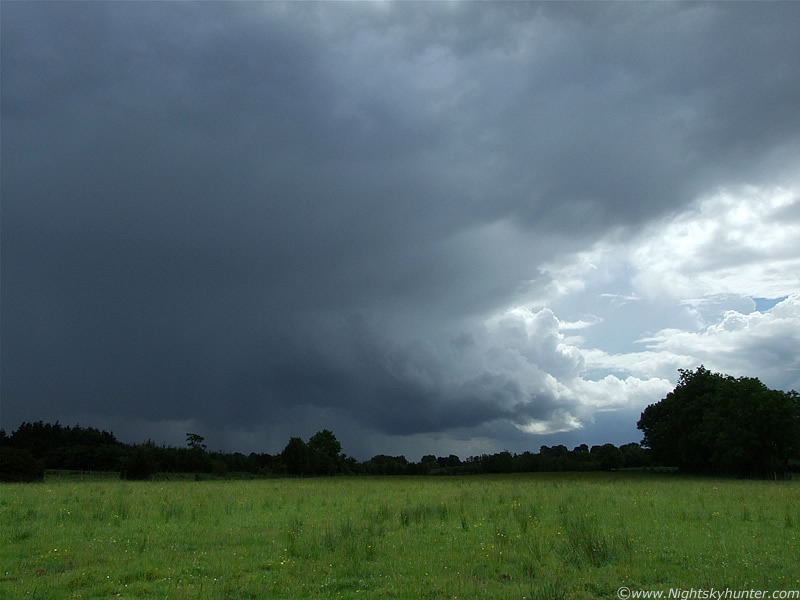 |
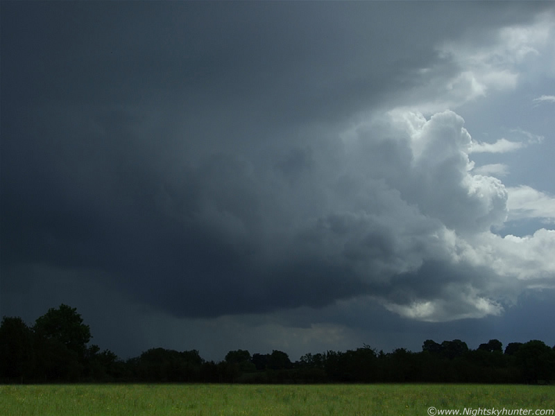
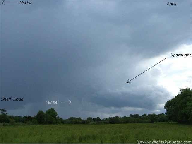
I found the perfect location in the countryside providing me with a decent view of the S skyline, with the exception of a few trees and hedges, I could see almost to the ground. The first cell passed by me into the NE, it was very slow moving and seemed to hang around over a field for a long time releasing an intense dark precip core. On the image is the second cell which was very low to the ground and the most interesting of the two. By this stage it had already turned into a thunderstorm. I could see blue c-gs and I-c bolts within the that falling precip below the cell followed by distant rumbles of thunder. Cell is moving very slowly from R to L. To the L is the dark outflow area where the precip is falling along with lightning/thunder, to the R of this is the flanking area of the storm where the main updraught is located along with new updraught towers at the back which were exploding up all the time. Below the updraught is the rain free base (RFB), which is dead centre in the image, that's the area to look for a funnel or tornado. Sweeping up from all of this is the dark anvil which extends far out of frame. There was alot going on here.
 |
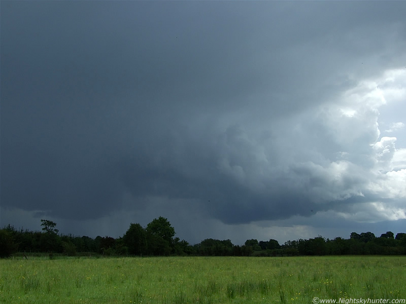
Zooming in a little to the flanking line/RFB. I was having such a great time here standing in this gorgeous green field under intense sunshine in high temps with just a t-shirt catching some rays while at the same time watching a thunderstorm. I wasn't in any real danger either because the lightning was a good bit away and with the storm passing by in front of me I wouldn't even get wet. That makes a change!. It was so hot, calm, and peaceful, with just the birds singing along with rumbles of thunder.
 |
Then I heard more thunder from behind me, I turned around and saw that the first cell was now a thunderstorm, so I was between the two of them now. Looking back to the first storm I crossed my fingers for a funnel, I was perfectly placed to catch one.
 |
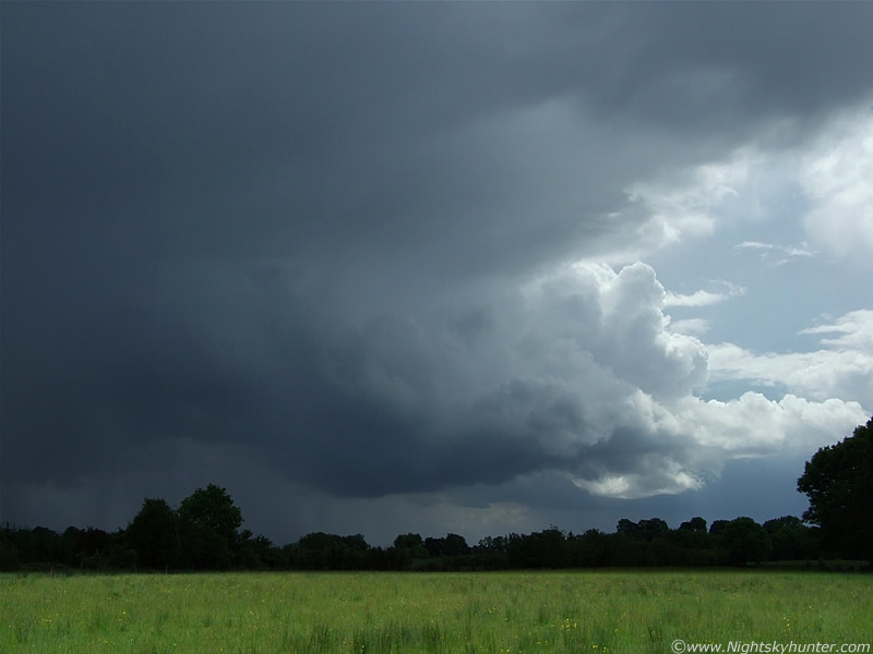
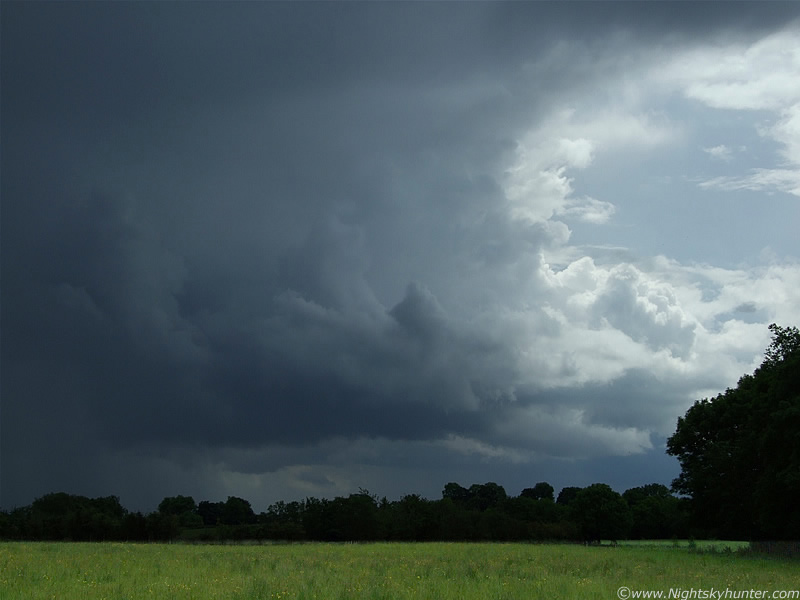
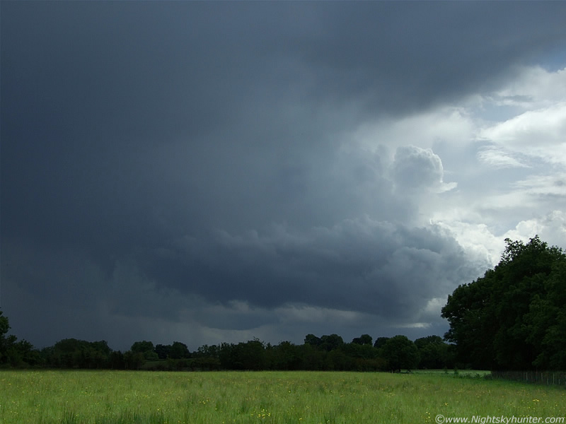
This image is slightly overexposed, the storm was alot darker in reality but taking images was difficult due to the dynamic range in brightness. The Sun brightly reflecting off the flanking area. A shelf cloud was forming to the far L. The black dots in the image are flies. Some really good multiple rumbles at this time. Much of the lightning was hitting down on the S side of the storm on the other side of the precip so I would just hear thunder without seeing the bolt, although the ones which hit on this side were plain to see.
 |
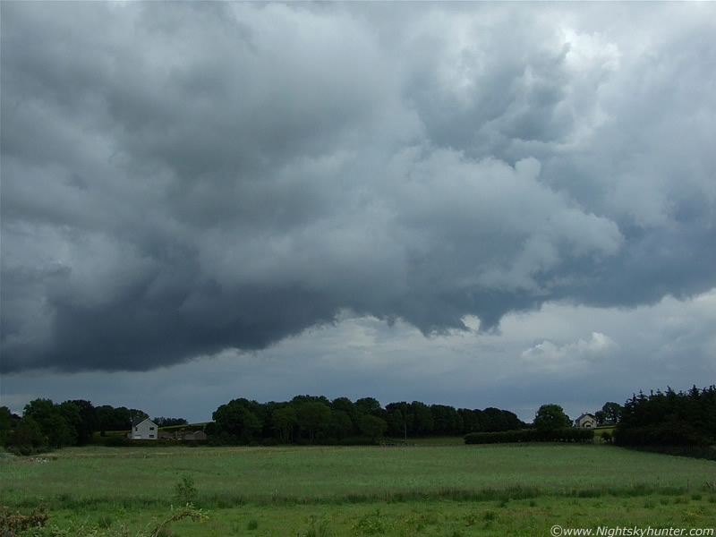
Back to the flanking area which was like an organized conveyor belt producing new updraught towers and feeding them in to the cell.
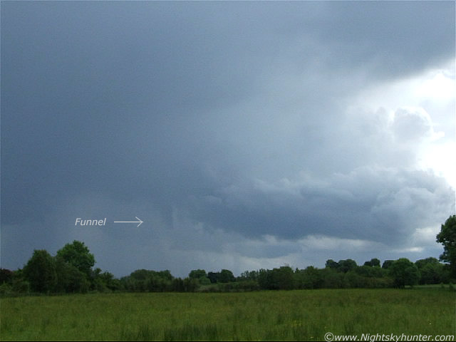 |
Days after this I had made a short video clip which I uploaded to youtube, I never really got a chance to study it properly until recently. When I did I was shocked to see a very obvious funnel cloud in the video located at the inflow/outflow interface. On the video I could clearly see it spinning...like crazy!. I was convinced, however I checked the original high res video clip for a better look and sure enough it was extremely easy to see. The rotation was really impressive. Above and below are two stills from the video. The funnel looks ragged only because I sharpened the images which broke it up a little.
 |
I annotated the still to show the main storm features. I can't believe I missed seeing this at the time. What happened was that I was taking the video with the camera mounted on the tripod but I left it there because I kept watching behind me at the other storm, so I must have missed it during this period.
 |
Here's the only still image I have showing the remains of the funnel as it decayed, now looking nothing more than a piece of scud. It's a pity I hadn't caught on to this at the time because I could have got a great zoom image of the funnel. More new towers going up again at the rear followed by more thunder.
 |
This is looking E at the area ahead of the storm. The outflow area from the storm had acted like a cold front and developed more stunning towers which looked like a funnel breeding ground. I was trying to get some images of those huge towers but before I could get focused mid level cloud raced across the sky and covered them. That's what's happening in the above image. Plenty of scud spikes with dynamic motions below but no more funnels.
Here's the short video clip. Nothing really exciting just a few rumbles of thunder and the funnel. Look very carefully and you will see it spinning rapidly.
After this I changed location and watched more incredible convection, this time arriving from the W. I watched a breathtaking cell in the north shoot up to an eye-catching height and mushroom out into a gorgeous anvil with hail dripping from its sides as virga. It had another powerful flanking line feeding into the rear and the entire thing was almost brushing the fields, it was that low. A local farmer on his quad drove across country to ask what I was doing but once he seen me he knew who I was and what I was doing, we a chat about the storms today and then he left me to it. After this the sky cleared up very well so I decided to go back home. Not a bad day at all, two local storms and a funnel cloud. However, that was not the end of the excitement as yet another funnel would reveal itself to me later that very evening, I will save that one for my last report.
Martin McKenna